
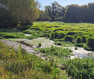
Our Catchment
The River Pang and Sulham Brook are chalk streams in West Berkshire and tributaries of the River Thames
The main channel of the River Pang begins near the village of Compton and flows for 23km to its confluence with the Thames at Pangbourne. When groundwater levels are high the Pang can flow as far upstream as West Ilsley. The Pang has minor tributaries, including the River Bourne which joins 5 km upstream of Pangbourne.
The Sulham Brook is a smaller tributary to the Thames, running for 6 km from its source just north of Theale, before flowing through Sulham and into the Thames East of Pangbourne by Saltney Mead. For much of the length of the Sulham Brook these two rivers run parallel, often with less than 1km separating them.
Both rivers are fed by springs of cold and clear groundwater that rise from the chalk aquifer along their length. Their flow in upper reaches is seasonal (aka ephemeral or winterbourne) following local groundwater levels.
The Pang is ephemeral upstream of the Blue Pool, near Stanford Dingley, approximately 10 km from the confluence with the River Thames. The upper reaches of the Sulham Brook are fed by springs in the chalk and gravels, and it is prone to winter flooding and summer drying.
River Catchment Status
The Environment Agency assesses the condition of waterbodies (including the Pang and Sulham Brook) under the Water Framework Directive (WFD), classifying waterbodies from ‘High’ to ‘Bad’ status, with ‘Good’ or better classification the general objective for all waterbodies. Overall waterbody status is aggregated across ecological, morphological and chemical elements. The ecological status of a waterbody is of particular interest, comprising assessments of invertebrates, macrophytes and fish as well as phosphate and dissolved oxygen (amongst others). WFD classifications from 2022 found the ecological statuses of the Pang and Sulham Brook to be Poor and Moderate, respectively.
")
Water Framework Directive Classification (WFD)
The Challenges

Low flows and water abstraction
The Pang relies on groundwater from the chalk aquifer. Over-abstraction for public water supply and agriculture can reduce spring flows, particularly during dry periods. Low flows not only harm aquatic habitats but also concentrate pollutants and raise water temperatures, making life difficult for sensitive chalk stream species like brown trout, mayfly and stream water crowfoot.
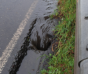
Pollution and water quality
Runoff from roads, treatment works, septic tanks, and farmland introduces nutrients, silt, and chemicals into the river. Elevated levels of phosphorus and sediment can smother gravels, reduce oxygen levels, and trigger algal growth, damaging the natural balance of the stream. Addressing diffuse pollution remains one of the biggest challenges for improving the Pang’s water quality.

Physical modifications
Historic land drainage, mill structures, and channel straightening have altered the Pang’s natural form and flow. These changes disconnect the river from its floodplain, reduce habitat diversity, and limit the river’s ability to recover from floods or droughts. Restoring more natural features — such as meanders, woody debris, and wetland fringes — is key to building a healthier, more resilient river.
Climate change
Extremes in rainfall and temperature and long term warming are likely to exacerbate existing issues affecting chalk stream systems. Dryer summers and wetter winters predicted could put strain on the Pang’s natural flow and ecology. Nature-based solutions, sustainable water use, and climate resilient interventions will be essential to help the river adapt to changing climate.
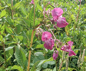
Invasive non-native species
Species such as Himalayan balsam and signal crayfish are spreading through parts of the catchment, outcompeting native plants and animals and altering the river’s natural balance. Coordinated monitoring and community action are vital to prevent further spread and to restore native biodiversity.